It's been a while since I last posted anything and that's mainly because I've been in France backpacking the 415 mile Grand Traverse of the Alps (GTA) with my girl, Megan. The route starts at Lake Geneva and ends at the Mediterranean Sea but at which town depends on the route you take at the very end. Ever since I introduced my girlfriend to long distance backpacking on the John Muir Trail last summer I've been thinking of the next trip. After my 2009 backpacking adventure of the famous 168km Tour du Mont Blanc, otherwise known as TMB, in France, Italy, and Switzerland I wanted to do something bigger that would see more of the Alps. Out of the several options given (GR10,11,7) we decided on the 400-420 mile GR5. Given our limited time in the summer we needed something that was well-marked and that could be completed in around 3 weeks. Fast-forward to the June 23 in Geneva, we were set to take a bus to Thonon-les-Bains at the edge of Lake Geneva to start the trip south.
The trail philosophy in Europe is quite different than here in the US. For starters in France the trails tends to pass through villages and hamlets much more often, no matter how useless those places are to a hiker. A town in the US and in the Alps are completely different in the sense that we were very lucky if a hamlet provided anything for the thru-hiker; ie markets, sporting good shops, places to eat. What you usually got was a taste of the culture and the sense of history surrounding these places. So with different cultures comes different philosophies on the most basic of things such as when a restaurant or market is open. In the US if you stopped in a town there would no doubt be several fast food chains, markets, and gas stations with marts that would be 18-24hrs/day. However, if we were fortunate enough to happen upon an épicerie (small shop) they would be closed from 12pm-4pm because that's the way the French do things. You're looking for something to eat? The kitchen doesn't open until 7pm. So if you arrive at 2pm, as we typically did in certain places, good luck finding the single shop open. Coming from the land of convenience it was frustrating at first. However, as time went on and we adjusted it was a refreshing take on our whole approach to life. There are also mountain huts, or réfuges, day hikes away from each other that provide dorm like rooms, dinner, and/or breakfast at a price 33-45 Euros. Pretty expensive for a hike of our magnitude but reasonable for weekend hikers. However, we did it 4 times and got to experience the uniqueness of each place while sharing a communal meal.
I'm not going to talk about each single day and just recount what happened but I will talk about the trip in general terms. The first few days were very tough mentally and physically and that was because the weather had been poor and according to people that previous week had seen winter-like conditions. What that resulted in was excessively muddy trails in combination with some the steepest trails I've hiked on; think 1500ft gain in less than 1 mile as commonplace. Megan also was just recovering from a severely sprained ankle back in June so she had just been swimming for the past several weeks; obviously not the same as shlepping a pack up steep mountains. On top of that we were jet-lagged since we hiked 10 miles stepping of the plane that afternoon. However, after those first several days of adjustment to the trail and time-zone we started to get into the groove of things. Day 6 saw our first real great weather day as we walked along the magnificent ridges of Crete des Gittes. From that point on the weather was fairly good with only one real all-day deluge and some mild rains here and there. What was a saving grace was that we knew the further south we went the better the weather was going to get.
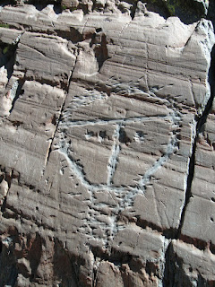
After getting through the muddiest day of the GTA on that same day the trail began to have consistently descent footing. We soon passed through the magnificent Parc National de Vanoise and quickly hiked through the corporation-deluged ski town of Tinges-le-Lac. From there we took a variant route that stayed in the valley a bit more and thus save some time which would later allow us to finish on the longer GR52. After camping behind a town's outdoor crucifix at Valfréjus and sending out postcards we hit the weird little village of Plampinet. Megan claims to have heard Bojangles outside our tent during our bivouac that night but who really knows. We then passed through the beautiful Pac Naturel Régional Du Queyras after surviving the biggest town on the trek, Briancon. We were wandering the streets for a while before we got to the very cool town campground where we met the owner's older son Charles, a lumberjack that had worked at Grant's Pass in Oregon. We exited the Parc Naturel on what I think is the best mountain view I've ever seen on top of the Col Girardin. One could see this stretch of rugged mountains stretching back to Mont Blanc that was simply something I was in awe of. Two days later a cyclone had made it's way to southern France where potential lightening was going to happen, and this was the day we had to cross over 4 cols, including Pas de la Cavale, a pass dividing two different french alp regions. Unfortunately, the great views from that col were non-existent. Three days later we camped well away from a private farm refuge on the border of the Parc National du Mercantour where wolves were rapidly procreating after a re-introduction. The dogs soon spent the night running around the surrounding forests to keep the wolves away from the sheep. However, in the middle of the middle of the night Megan's food-filled pack was being dragged away from the tent from a suspected wolf. I yanked it back but couldn't see anything because of the lack of a headlamp. When we reached St. Dalmas we parted ways with the GR5, which would continue boringly to the large city of Nice, and went on the longer and more rugged GR52 that would pass through the heart of the national park. What wasn't expected were class III scrambles over talus surrounded passes that became the hardest days of the entire trip (think 25-27 mile days with 10,000+ ft. of gain). However, that was rewarded with being able to not only witness great views but ancient petroglyphs from the Bronze Age (3200-600BCE). This is when my shoes had finally deteriorated into useless cloth and now the sole of my foot became the cushioning. Unfortunately over very rugged terrain they didn't last long. The last day and a half felt like I was walking on needles and not only that when I would stand still the blood pooling in my feet would make it much worse. We reached the Mediterranean soon and were we were very sad that it was over. It provided us with an experience of a lifetime that I will never forget. Here is a link to the
photos. I hope you enjoy them.
Days: 21
Miles: 415
Elevation gain: 117,240 ft
*in comparison: Colorado Trail: 470 miles 65K ft.,
John Muir Trail (if doubled) 422 miles 92K ft.


as always... amazing trip and pictures! I love hearing about your adventures.
ReplyDeleteHoly cow! I am so jealous of you guys. I was drooling looking at the scenery in the photo album. I'm definitely putting this on my list of things to do before I die. I'd love to hear about the trip in person next time we see each other. Probably the kickoff now that the Onion is gone. Hope you guys are doing well and your feet have healed.
ReplyDeleteWell, I hope it's not until the KO; maybe Megan and I will come up north one of these days for a trail run or something! In regards to the GTA, hell yes, put it on your list of things to do!
ReplyDelete